
Maps & hidden lands
Buache knew subglacial Antarctic divisions
Cartographic interpretationEvidence status
Unsupported identification
Its speculative geography does not demonstrate knowledge of subglacial terrain.
Editorial assessment of this proposition; not a numeric confidence score.
Claim or proposition being examined
Buache’s map reveals Antarctic land divisions beneath modern ice.
Limitations
Documentation establishes historical circulation of the claim, not its truth; see counterevidence and source roles.
Scope of catalog verification
Source existence and described claim checked via web search/excerpts; not independent validation of alleged event.
Material cited and its limits
Buache southern lands map, 1739 catalog record — Keep this map distinct from 1754 states and modern subglacial interpretations.
Research context
BedMachine Antarctica version 3 is a scientific bed-elevation model. It is not a direct image of an ancient ice-free coastline or evidence of a lost civilization.
Read the cited research contextCatalog review date reported: 2026-10-28. This is inherited catalog metadata, not a new verification of the linked source.
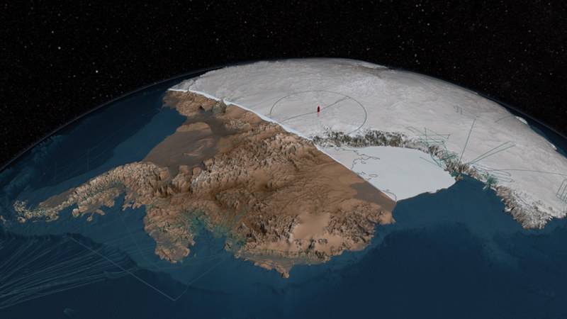
Scientific visualization of Bedmap2 bedrock and ice layers (2013). This is a data-derived reconstruction, not a photograph of an ice-free Antarctic continent. NASA’s Goddard Space Flight Center; Bedmap2 data led by British Antarctic Survey Scientific source ↗
Image source record
Image rights and evidence limits
NASA media guidelines permit factual educational/informational website use. Item credits NASA GSFC and includes no third-party restriction notice. No endorsement implied.
Image existence does not prove a linked claim. Consult image-specific captions and reuse conditions.
Sources and what they support
Links document the record, the claim’s circulation, an assessment, or reuse terms as labeled. A source link is not automatically corroboration.
- Example stating the claimhttps://williamjohncox.com/assets/pdfs/books/MillennialMath.pdf
- Comparison and criticismhttps://talkorigins.org/faqs/mom/atlantis.html
- Primary institutional context; not proof of the speculative claimhttps://nsidc.org/data/nsidc-0756/versions/3
- Keep this map distinct from 1754 states and modern subglacial interpretations.https://catalogue.bnf.fr/ark:/12148/cb40641130s
- Scientific visualization context, not proof of speculative interpretationhttps://svs.gsfc.nasa.gov/11274/
Connected records
These are contextual links, not automatic corroboration.
- The world beneath the ice.
Modern bed-elevation models offer comparison material; they do not demonstrate that an early cartographer had equivalent measurements.
- Buache’s map of the southern lands
The 1754 southern chart provides a concrete original for comparison. Keep its date and state distinct from other Buache maps and modern bedrock models.
- Oronce Fine records preglacial Antarctica
Compare the logic used to identify southern land across different maps, dates and editions.
Explore the same topic
- flat-earth allegation
Antarctic circumferential ice wall
Contradicted by surveys, navigation and satellite observations.
- Historical sighting
Dougherty Island
The described island was not confirmed by later searches.
- flat-earth allegation
Drilling the firmament
Claimant explicitly cannot identify or authenticate the alleged witness.
- Historical sighting
Emerald Island
Repeated searches did not establish the charted island.