
Maps & hidden lands
Oronce Fine records preglacial Antarctica
Cartographic interpretationEvidence status
Unsupported identification
Conjectural southern geography is not evidence of a measured Antarctic coastline.
Editorial assessment of this proposition; not a numeric confidence score.
Claim or proposition being examined
Fine’s southern continent preserves a real survey of Antarctica before major ice cover.
Limitations
Related map hypothesis; do not count reproduction editions as new theories.
Scope of catalog verification
Source existence and described claim checked via web search/excerpts; not independent validation of alleged event.
Material cited and its limits
Fine double-heart world map: 1531 signature, BnF impression[1532] — This edition-specific original differs from the 1534 single-heart map.
Catalog review date reported: 2026-10-28. This is inherited catalog metadata, not a new verification of the linked source.
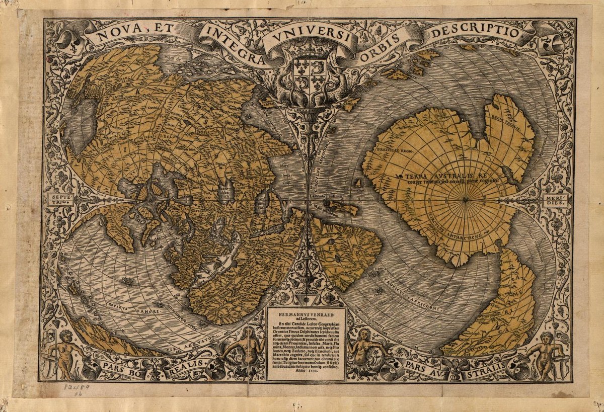
Finé double-heart world map, LOC catalog date 1531, with Hermannus Venraed inscription. This LOC copy differs from the BnF [1532] impression cited in the claim record. Conjectural Terra Australis is not proof of preglacial Antarctic surveying.
Oronce Finé (1531). Library of Congress, Geography and Map Division, G3200 1531 .F5, LCCN 2005630228; World Digital Library.
Image source record · Reuse terms
Image rights and evidence limits
LOC World Digital Library reports no known copyright or other restrictions; free use and reuse absent restrictions.
Image existence does not prove a linked claim. Consult image-specific captions and reuse conditions.
Sources and what they support
Links document the record, the claim’s circulation, an assessment, or reuse terms as labeled. A source link is not automatically corroboration.
- Documents map-based thesishttps://books.google.com/books/about/Maps_of_the_Ancient_Sea_Kings.html?id=5iLG2D5eBswC
- Map-specific critical analysishttps://cdn.centerforinquiry.org/wp-content/uploads/sites/29/1986/10/22165322/p34.pdf
- This edition-specific original differs from the 1534 single-heart map.https://catalogue.bnf.fr/ark:/12148/cb40699514m
- image reproduction provenance; not proof of a linked interpretationhttps://www.loc.gov/item/2005630228/
- image reuse conditionshttps://www.loc.gov/resource/g3200.ct001393/?sp=1
Connected records
These are contextual links, not automatic corroboration.
- Oronce Fine’s double-heart world map
Compare the claim with Fine’s double-heart map and the specific BnF impression, rather than substituting a different edition.
- Piri Reis depicts an ice-free Antarctic coast
Both infer ancient Antarctic knowledge from old maps, but they concern different originals and must be tested separately.
- Buache knew subglacial Antarctic divisions
Compare the logic used to identify southern land across different maps, dates and editions.
- Oronce Fine world map, 1534
This different Fine map is useful for an edition comparison, not interchangeable proof for the 1531 map claim.
Explore the same topic
- flat-earth allegation
Antarctic circumferential ice wall
Contradicted by surveys, navigation and satellite observations.
- Cartographic interpretation
Buache knew subglacial Antarctic divisions
Its speculative geography does not demonstrate knowledge of subglacial terrain.
- Historical sighting
Dougherty Island
The described island was not confirmed by later searches.
- flat-earth allegation
Drilling the firmament
Claimant explicitly cannot identify or authenticate the alleged witness.