
Maps & hidden lands
Piri Reis depicts an ice-free Antarctic coast
Cartographic interpretationEvidence status
Unsupported identification
Cartographic criticism finds no demonstrated accurate Antarctic survey.
Editorial assessment of this proposition; not a numeric confidence score.
Claim or proposition being examined
The southern coast on Piri Reis’s 1513 map represents ice-free Antarctica.
Limitations
Map existence is genuine; the Antarctic interpretation is the claim.
Scope of catalog verification
Source existence and described claim checked via web search/excerpts; not independent validation of alleged event.
Material cited and its limits
Piri Reis world map fragment, 1513 — The source authenticates the historical artifact, not the ice-free Antarctic interpretation.
Catalog review date reported: 2026-10-28. This is inherited catalog metadata, not a new verification of the linked source.
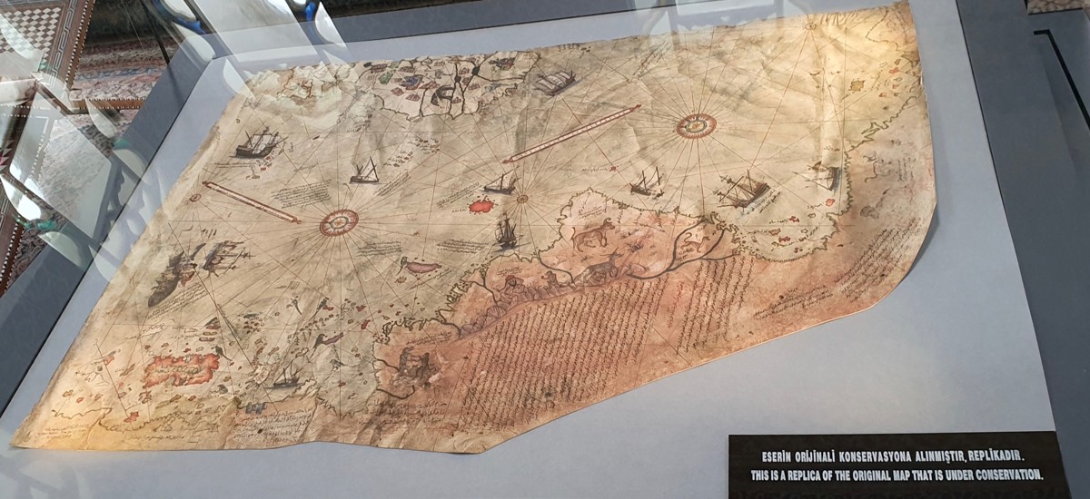
Museum-display REPLICA of the 1513 Piri Reis map, Yair Haklai 2023, CC BY-SA 4. The original is not pictured. This image documents the replica, not an ice-free Antarctic coast.
Yair Haklai, 16 April 2023, Wikimedia Commons, CC BY-SA 4.0. Proportionally resized; otherwise unchanged.
Image source record · Reuse terms

Image rights and evidence limits
CC BY-SA 4.0, photographer own-work release on exact source file page. Attribution, license link, change disclosure; adaptations share alike.
Image existence does not prove a linked claim. Consult image-specific captions and reuse conditions.
Sources and what they support
Links document the record, the claim’s circulation, an assessment, or reuse terms as labeled. A source link is not automatically corroboration.
- Hapgood hypothesis historyhttps://archive.aramcoworld.com/issue/198001/piri.reis.and.the.hapgood.hypotheses.htm
- Cartographic criticismhttps://cdn.centerforinquiry.org/wp-content/uploads/sites/29/1986/10/22165322/p34.pdf
- The source authenticates the historical artifact, not the ice-free Antarctic interpretation.https://www.unesco.org/en/memory-world/piri-reis-world-map-1513
- image reproduction provenance; not proof of a linked interpretationhttps://commons.wikimedia.org/wiki/File:A_peculiar_map_drawn_by_the_Turkish_admiral_Piri_Reis_around_1513.jpg
- image reuse conditionshttps://creativecommons.org/licenses/by-sa/4.0/
Connected records
These are contextual links, not automatic corroboration.
- Piri Reis world map fragment
This is the exact historical fragment discussed by the Piri Reis interpretation; artifact provenance and the claimed Antarctic identification are separate questions.
- Ancient Antarctica, Giant Pyramids and the Piri Reis Map: Fact or Fiction? | Ancient Architects
Related creator video. The catalog examines the same Piri Reis–Antarctica interpretation. A related link is not an endorsement of the interpretation.
- SCAMTARCTICA 3 - Fantasy Island - Globe vs Flat Earth
Related creator video. The catalog examines the same Piri Reis–Antarctica interpretation. A related link is not an endorsement of the interpretation.
- The Piri Reis Map: Did Aliens Discover Antarctica? | It's Probably (not) Aliens! #8
Related creator video. The catalog examines the same Piri Reis–Antarctica interpretation. A related link is not an endorsement of the interpretation.
- The Piri Reis Map: Clue To A Civilization Buried Under Antarctic Ice?
Related creator video. The catalog examines the same Piri Reis–Antarctica interpretation. A related link is not an endorsement of the interpretation.
- Oronce Fine records preglacial Antarctica
Both infer ancient Antarctic knowledge from old maps, but they concern different originals and must be tested separately.
Explore the same topic
- flat-earth allegation
Antarctic circumferential ice wall
Contradicted by surveys, navigation and satellite observations.
- Cartographic interpretation
Buache knew subglacial Antarctic divisions
Its speculative geography does not demonstrate knowledge of subglacial terrain.
- Historical sighting
Dougherty Island
The described island was not confirmed by later searches.
- flat-earth allegation
Drilling the firmament
Claimant explicitly cannot identify or authenticate the alleged witness.