
Polar & expedition maps
Buache’s map of the southern lands
Historical recordA southern-region chart compiled from Bouvet de Lozier’s expedition material. The BnF dates this edition to 1754. It is not a modern subglacial survey and is distinct from later Buache maps.
What this record establishes
Institutional record documented; does not authenticate interpretations.
Record details
- Original title
- Buache’s Carte des terres australes
- Artifact date
- 1754
- Holding institution
- Bibliothèque nationale de France
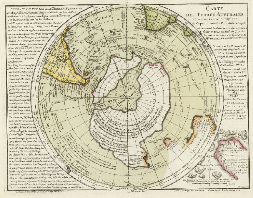
Buache’s Carte des terres australes, dated 1754 on the map, shown from the independent David Rumsey atlas copy (atlas catalogued 1770?). This is not the BnF physical sheet. Its conjectural southern geography is not a modern survey beneath Antarctic ice.
Philippe Buache, after Bouvet de Lozier and Guillaume Delisle; engraved by G. Delahaye. David Rumsey Map Collection, David Rumsey Map Center, Stanford University Libraries, 5698.002.
Map dated 1754; containing atlas catalogued 1770 with uncertainty in full title (1770?). Different physical copy from BnF FRBNF 40592237. Preserve both dates/copy distinction.
Image source record · Reuse terms
Image rights and evidence limits
David Rumsey current policy expressly permits use in print/digital publications by for-profit or nonprofit publishers without charge, with credit. Underlying 1754 map is historical public-domain work. General archive license CC BY-NC-SA 3.0 also recorded; relying on the separate express current publication permission, not claiming CC BY 4.0. Stand-alone for-sale facsimile reproduction requires permission. Exact source record exposes Download 1.
Image existence does not prove a linked claim. Consult image-specific captions and reuse conditions.
Sources and what they support
Links document the record, the claim’s circulation, an assessment, or reuse terms as labeled. A source link is not automatically corroboration.
- image reproduction provenance; not proof of a linked interpretationhttps://www.davidrumsey.com/luna/servlet/detail/RUMSEY~8~1~25808~1080049:Terres-Australes-
- image reuse conditionshttps://www.davidrumsey.com/about/copyright-and-permissions
- institutional or documentary recordhttps://catalogue.bnf.fr/ark:/12148/cb40592237k
Connected records
These are contextual links, not automatic corroboration.
- Buache knew subglacial Antarctic divisions
The 1754 southern chart provides a concrete original for comparison. Keep its date and state distinct from other Buache maps and modern bedrock models.
Explore the same topic
- Historical record
Adélie Land sledge route — Australasian Antarctic Expedition
Separately numbered original manuscript in the Australasian Antarctic Expedition records; inventory item 17, 64cm x 91cm. Nunatak. Commonwealth Bay. Cape Pigeon Rookery.
- Historical record
Amundsen’s South Pole expedition routes
A separately catalogued expedition or regional map; scale 1 : 6 000 000. It records historical cartographic knowledge, not evidence of hidden continents.
- Historical record
Antarctic chart annotated by Captain J. K. Davis
Annotated nautical chart preserved in the Davis collection, NAA P2819.
- Historical record
Antarctic exploration map by Bayliss
South-centered azimuthal equidistant map compiles Antarctic exploration.
Browse Polar & expedition maps Open the original vault record