
World maps & models
Al-Idrisi’s world map — a sixteenth-century copy
Historical recordOrientation is a cartographic convention, not inversion of the physical Earth.
What this record establishes
Institutional record documented; does not authenticate interpretations.
Record details
- Original title
- Al-Idrisi world map, MS Pococke 375
- Artifact date
- 1553 copy of medieval work
- Creator
- Copyist after al-Idrisi
- Holding institution
- Bodleian Libraries
- Classification
- South-up world map
Antarctica connection
Contextual visual history; not direct evidence about Antarctica
Relevance and caution
Orientation is a cartographic convention, not inversion of the physical Earth.
Catalog context
Curatorial navigation label; original categories and source identity retained.
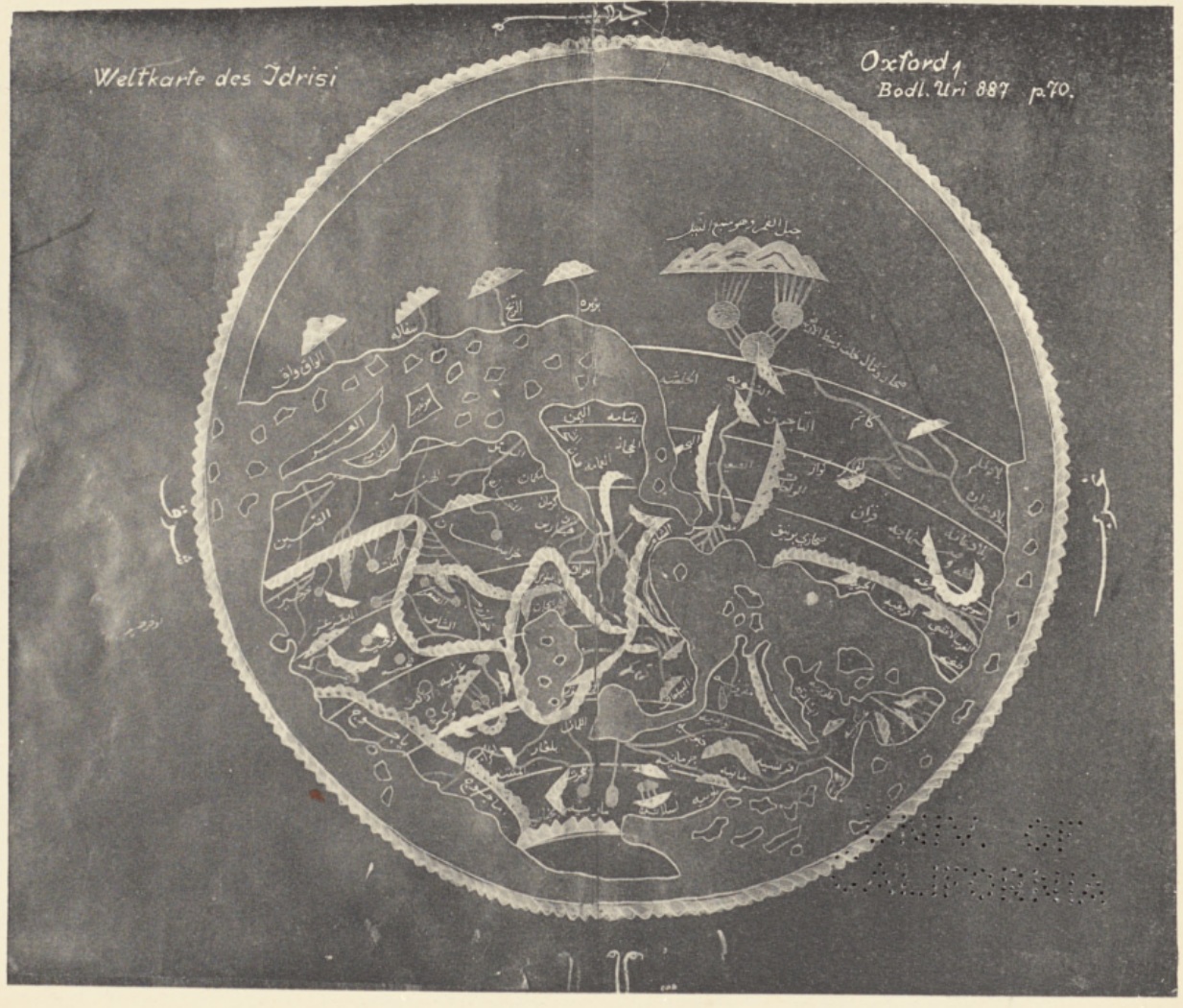
World map identified in the 1927 plate as Oxford 1, Bodleian Uri 887 (now MS Pococke 375, the 1553 manuscript). Independent monochrome printed facsimile from Miller’s Idrisi-Atlas, not a modern Bodleian photograph or a reconstruction.
Konrad Miller (ed.), Mappae Arabicae VI: Idrisi-Atlas (Stuttgart, 1927), plate II. Selections from the Library, fGA302 M5 v.6, UC Berkeley Library, University of California, Berkeley. Public domain.
The manuscript identity is confirmed by the scholarly crosswalk Uri 887 = Pococke 375. Miller labels the reproduced image p.70 and describes another enlarged two-page version; the modern catalog describes fols.3v–4r. Exact folio/exposure equivalence is not asserted. The modern Bodleian manuscript photograph is linked separately and not reproduced. South-up orientation is preserved. This is historical cartography, not evidence of Antarctica.
Image source record · Reuse terms
Image rights and evidence limits
Public-domain 1927 printed facsimile, independently digitized by UC Berkeley Library. The volume title page dates this edition 1927; editor Konrad Miller died in 1933. Berkeley permits free and open reuse of its online public-domain reproductions without permission, with source attribution requested. This does not license modern Bodleian or HU Berlin digitizations.
Image existence does not prove a linked claim. Consult image-specific captions and reuse conditions.
Sources and what they support
Links document the record, the claim’s circulation, an assessment, or reuse terms as labeled. A source link is not automatically corroboration.
- displayed image provenance; not proof of a linked interpretationhttps://digicoll.lib.berkeley.edu/record/206598/files/B131238073_C003363017.pdf#page=11
- image-specific reuse conditionshttps://www.lib.berkeley.edu/about/permissions-policies
- documentary target record; may differ from displayed reproductionhttps://digital.bodleian.ox.ac.uk/objects/ced0d8bd-1019-4af2-9086-e411115f1507/
- institutional or documentary recordhttps://digital.bodleian.ox.ac.uk/objects/ced0d8bd-1019-4af2-9086-e411115f1507/
Explore the same topic
- Historical record
Abizaid’s flat, stationary-Earth map
John George Abizaid’s map with English and Arabic text.
- Historical record
Babylonian Map of the World
Disc and surrounding cosmic waters; ancient worldview, not an Antarctic survey.
- Historical record
Bertelli’s map of the known world
Southern land and fantastic fauna are speculative; do not label them surveyed ice-free Antarctica.
- Historical record
Cosmas’s ancient world model — nineteenth-century tracing
Kohl’s nineteenth-century tracing of a Cosmas reconstruction.