
Polar & expedition maps
Map of Endurance’s drift through Antarctic waters
Historical recordA separately catalogued expedition or regional map; scale 1 : 7 500 000. It records historical cartographic knowledge, not evidence of hidden continents.
What this record establishes
Institutional record documented; does not authenticate interpretations.
Record details
- Original title
- Antarctic Regions : chart to illustrate the paper on the Drift of the "Endurance" by Lieut. J.M. Wordie R.F.A.
- Artifact date
- April 1918
- Publisher
- Royal Geographical Society (United Kingdom)
- Holding institution
- Australian Antarctic Data Centre
- Accession
- AADC map 3700
- Projection
- Not Given
- Scale
- 1 : 7 500 000
Scope of evidence
Evidence of an original historical map or manuscript, not evidence of hidden lands or a non-spherical Earth.
Catalog context
A physical copy of this map is on permanent loan from the Australian Antarctic Division to the National Library of Australia, where it is available for viewing.
Holding note
A physical copy of this map is on permanent loan from the Australian Antarctic Division to the National Library of Australia, where it is available for viewing.
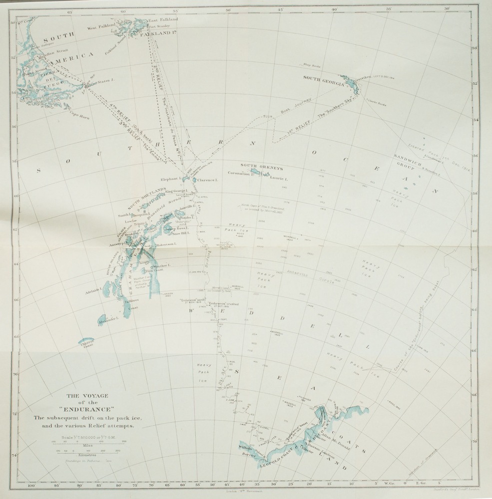
Related historical map: Endurance’s voyage, ice drift and relief attempts, published in Shackleton’s South (1919). Not Wordie’s RGS 1918 sheet.
Stanford’s Geographical Establishment, The Voyage of the Endurance, in Ernest Shackleton, South (London: William Heinemann,1919), foldout after p.368. Internet Archive scan via Wikimedia Commons.
Different historical map of same voyage, not the target 1918 RGS Wordie chart. Use only as clearly labeled supporting/context image; retain original record link and hold for exact scan.
Image source record · Reuse terms

Image rights and evidence limits
Public Domain Mark 1.0; Commons explicitly PD-old-70-expired and US pre 1931 publication.
Image existence does not prove a linked claim. Consult image-specific captions and reuse conditions.
Sources and what they support
Links document the record, the claim’s circulation, an assessment, or reuse terms as labeled. A source link is not automatically corroboration.
- image reproduction provenance; not proof of a linked interpretationhttps://archive.org/details/South00Shac
- image reuse conditionshttps://commons.wikimedia.org/wiki/File:South_-_the_story_of_Shackleton%27s_last_expedition,_1914-1917_-Map.jpg
- institutional or documentary recordhttps://data.aad.gov.au/aadc/mapcat/display_map.cfm?map_id=3700
Connected records
These are contextual links, not automatic corroboration.
- Endurance22: Protecting Endurance and the Antarctic Treaty
Related creator video. Historical map of the Endurance drift complements the expedition or wreck discussion. The video is not asserted to cite this exact artifact.
- Sir Ranulph Fiennes On Why Ernest Shackleton Was The "Greatest Polar Explorer"
Related creator video. Historical map of the Endurance drift complements the expedition or wreck discussion. The video is not asserted to cite this exact artifact.
- Endurance: How A Stranded Crew Survived 2 Years In Antarctica | Great Adventurers | Absolute History
Related creator video. Historical map of the Endurance drift complements the expedition or wreck discussion. The video is not asserted to cite this exact artifact.
- The end of Endurance, 1915 | BFI National Archive
Related creator video. Historical map of the Endurance drift complements the expedition or wreck discussion. The video is not asserted to cite this exact artifact.
- Underwater robots find Shackleton's Endurance shipwreck in Antarctic - BBC News
Related creator video. Historical map of the Endurance drift complements the expedition or wreck discussion. The video is not asserted to cite this exact artifact.
- The Priceless Objects That Saved The Lives Of Shackleton And All His Men
Related creator video. Historical map of the Endurance drift complements the expedition or wreck discussion. The video is not asserted to cite this exact artifact.
- Shackleton's ship Endurance discovered after more than 100 years at the bottom of the sea
Related creator video. Historical map of the Endurance drift complements the expedition or wreck discussion. The video is not asserted to cite this exact artifact.
- How Did Shackleton Survive The Endurance Expedition?
Related creator video. Historical map of the Endurance drift complements the expedition or wreck discussion. The video is not asserted to cite this exact artifact.
Explore the same topic
- Historical record
Adélie Land sledge route — Australasian Antarctic Expedition
Separately numbered original manuscript in the Australasian Antarctic Expedition records; inventory item 17, 64cm x 91cm. Nunatak. Commonwealth Bay. Cape Pigeon Rookery.
- Historical record
Amundsen’s South Pole expedition routes
A separately catalogued expedition or regional map; scale 1 : 6 000 000. It records historical cartographic knowledge, not evidence of hidden continents.
- Historical record
Antarctic chart annotated by Captain J. K. Davis
Annotated nautical chart preserved in the Davis collection, NAA P2819.
- Historical record
Antarctic exploration map by Bayliss
South-centered azimuthal equidistant map compiles Antarctic exploration.
Browse Polar & expedition maps Open the original vault record