
Polar & expedition maps
Expedition map of Macquarie Island
Historical recordSeparately numbered original oversized, formerly at maxx 889.8/1913/1. in the Australasian Antarctic Expedition records; inventory item 12, .
What this record establishes
Institutional record documented; does not authenticate interpretations.
Record details
- Original title
- Macquarie Island
- Artifact date
- c1912-1913
- Creator
- Blake, Leslie Russell
- Holding institution
- State Library of New South Wales
- Accession
- Australasian Antarctic Expedition records, map 12
Scope of evidence
Evidence of an original historical map or manuscript, not evidence of hidden lands or a non-spherical Earth.
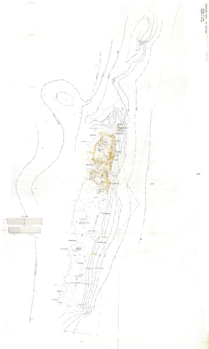
Leslie Russell Blake’s original 1913 manuscript survey map of Macquarie Island, at 1:40000. This is the exact map identified as item 12 in the Australasian Antarctic Expedition inventory, formerly MAXX 889.8/1913/1—not a modern reconstruction or the later printed simplified map.
Leslie Russell Blake (1890–1918), Macquarie Island R.F. 1:40000, 1913. State Library of New South Wales, MAXX 889.8/1913/1 (AAE map 12), digital file FL 14465886; Commons copy supplied by Shyamal. Public-domain assessment.
Institutional inventory dates c.1912–1913; individual collection page labels 1913. The inventory’s date range remains the basis of the artifact record. Macquarie Island is subantarctic, not mainland Antarctica.
Image source record · Reuse terms

Image rights and evidence limits
Public Domain Mark / life-plus-70 assessment on Commons; author Leslie Russell Blake died in 1918. SLNSW item page identifies published date 1913 and creator; Library general policy permits out-of-copyright collection material for any purpose including commercial use with acknowledgement. This is an independent expiry assessment, not an item-specific institutional licence. The current catalogue could not be rechecked; the Commons PD-old-70 template lacks a separate US tag. Underlying expiry assessment relies on the stated 1913 publication and 1918 death. Item-specific institutional clearance is not asserted.
Image existence does not prove a linked claim. Consult image-specific captions and reuse conditions.
Sources and what they support
Links document the record, the claim’s circulation, an assessment, or reuse terms as labeled. A source link is not automatically corroboration.
- displayed image provenance; not proof of a linked interpretationhttps://www.sl.nsw.gov.au/collection-items/macquarie-island-rf-140000-cartographic-material-lr-blake
- image-specific reuse conditionshttps://commons.wikimedia.org/wiki/File:Macquarie_Island_SLNSW_FL14465886.jpg#Summary
- documentary target record; may differ from displayed reproductionhttps://collection.sl.nsw.gov.au/record/74VKRBZ2RygM
- documentary target record; may differ from displayed reproductionhttps://content-lists.sl.nsw.gov.au/tabular-list/collection-maps-taken-australasian-antarctic-expedition-records-1910-1915
- institutional or documentary recordhttps://content-lists.sl.nsw.gov.au/tabular-list/collection-maps-taken-australasian-antarctic-expedition-records-1910-1915
Explore the same topic
- Historical record
Adélie Land sledge route — Australasian Antarctic Expedition
Separately numbered original manuscript in the Australasian Antarctic Expedition records; inventory item 17, 64cm x 91cm. Nunatak. Commonwealth Bay. Cape Pigeon Rookery.
- Historical record
Amundsen’s South Pole expedition routes
A separately catalogued expedition or regional map; scale 1 : 6 000 000. It records historical cartographic knowledge, not evidence of hidden continents.
- Historical record
Antarctic chart annotated by Captain J. K. Davis
Annotated nautical chart preserved in the Davis collection, NAA P2819.
- Historical record
Antarctic exploration map by Bayliss
South-centered azimuthal equidistant map compiles Antarctic exploration.
Browse Polar & expedition maps Open the original vault record