
Polar & expedition maps
Bransfield’s 1820 discoveries and route — later map
Historical recordA separately catalogued expedition or regional map; scale 1 : 2 650 000. It records historical cartographic knowledge, not evidence of hidden continents.
What this record establishes
Institutional record documented; does not authenticate interpretations.
Record details
- Original title
- Chart showing the discoveries and approximate track of Edward Bransfield, Master R.N. in the hired brig "Williams" of Blyth, when exploring the South Shetland Islands and the northern extremity of Graham Land in the year 1820.
- Artifact date
- March 1925
- Publisher
- Royal Geographical Society (United Kingdom)
- Holding institution
- Australian Antarctic Data Centre
- Accession
- AADC map 3701
- Projection
- Not Given
- Scale
- 1 : 2 650 000
Scope of evidence
Evidence of an original historical map or manuscript, not evidence of hidden lands or a non-spherical Earth.
Catalog context
Drawn by Lieut. Commander R.T. Gould, R.N. The coastline shown in red, has been copied in facsimile from Bransfield's chart, as published in 1822, by the Admiralty. The lettering in red has been transcribed from the original MS, chart. The remainder of the chart is based upon the most recent surveys.
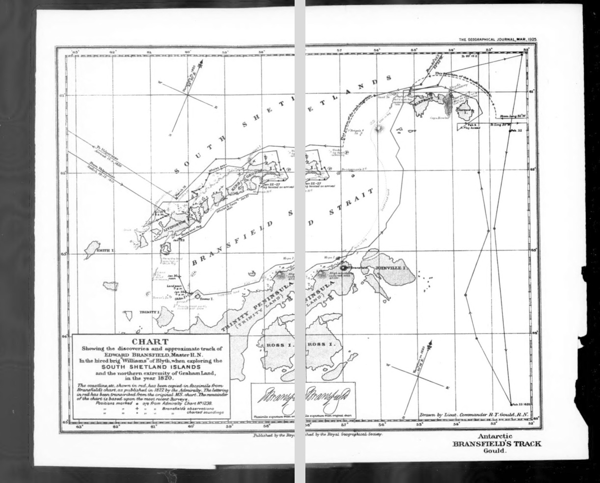
The 1925 chart drawn by R. T. Gould reconstructs Edward Bransfield’s 1820 voyage using his 1822 Admiralty chart and later surveys. Two original microfilm scan panels are shown side by side with a visible divider; they are not a seamless geographic reconstruction. The scan is monochrome, so the original chart’s red historical coastline coding cannot be read as color here.
R. T. Gould, Chart showing the discoveries and approximate track of Edward Bransfield (1925), The Geographical Journal 65(3), March 1925. Independent microfilm scan: Internet Archive, PDF pages 110–111. AADC map 3701 identifies the historical sheet.
Image source record · Reuse terms
Image rights and evidence limits
Independent copyright-expiry assessment, not an institutional reproduction license. Map explicitly drawn by R. T. Gould, published March 1925; Gould died 5 October 1948, confirmed by contemporary Polar Record obituary. Map is beyond U.S. publication term and UK life+70. Source charts by Edward Bransfield (d 1852) are older. Only the historical map image is included; no journal articles or modern editorial text. IA metadata does not assert a separate CC license; no restrictive image-specific term observed.
Image existence does not prove a linked claim. Consult image-specific captions and reuse conditions.
Sources and what they support
Links document the record, the claim’s circulation, an assessment, or reuse terms as labeled. A source link is not automatically corroboration.
- displayed image provenance; not proof of a linked interpretationhttps://archive.org/details/sim_geographical-journal_1925-03_65_3/page/n109/mode/2up
- image-specific reuse conditionshttps://www.gov.uk/copyright/how-long-copyright-lasts
- documentary target record; may differ from displayed reproductionhttps://data.aad.gov.au/aadc/mapcat/display_map.cfm?map_id=3701
- institutional or documentary recordhttps://data.aad.gov.au/aadc/mapcat/display_map.cfm?map_id=3701
Explore the same topic
- Historical record
Adélie Land sledge route — Australasian Antarctic Expedition
Separately numbered original manuscript in the Australasian Antarctic Expedition records; inventory item 17, 64cm x 91cm. Nunatak. Commonwealth Bay. Cape Pigeon Rookery.
- Historical record
Amundsen’s South Pole expedition routes
A separately catalogued expedition or regional map; scale 1 : 6 000 000. It records historical cartographic knowledge, not evidence of hidden continents.
- Historical record
Antarctic chart annotated by Captain J. K. Davis
Annotated nautical chart preserved in the Davis collection, NAA P2819.
- Historical record
Antarctic exploration map by Bayliss
South-centered azimuthal equidistant map compiles Antarctic exploration.
Browse Polar & expedition maps Open the original vault record