
Polar & expedition maps
Morning’s route on the second Antarctic relief expedition
Historical recordA separately catalogued expedition or regional map; scale 1 : 15 000 000. It records historical cartographic knowledge, not evidence of hidden continents.
What this record establishes
Institutional record documented; does not authenticate interpretations.
Record details
- Original title
- Map showing track of the S.Y. "Morning" to accompany Captain W. Colbecks report on the second Antarctic Relief Expedition 1903-04.
- Artifact date
- 1904
- Publisher
- Royal Geographical Society (United Kingdom)
- Holding institution
- Australian Antarctic Data Centre
- Accession
- AADC map 3686
- Projection
- Not Given
- Scale
- 1 : 15 000 000
Scope of evidence
Evidence of an original historical map or manuscript, not evidence of hidden lands or a non-spherical Earth.
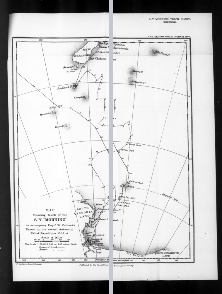
Two overlapping microfilm panels of the original 1904 chart documenting the Morning’s 1903–04 relief voyage. Grey gap separates the source scans; it is not a geographical gap. The chart records historical reports, including island names later questioned.
William Colbeck (1871–1930); Royal Geographical Society, The Geographical Journal, 1904. Internet Archive independent microfilm digitization. Public-domain expiry assessment; no institutional licence asserted.
Same named printed chart and publication year as AADC catalog; independent digitization, not clearance to reuse AADC preview pixels.
Image source record · Reuse terms
Image rights and evidence limits
Independent public-domain assessment, not a licence issued by Internet Archive: original English-language chart published in 1904 (public domain in the US by age), and its named creator(s) died no later than 1949 (more than 70 full years before 2026). No additional named engraver appears on the inspected printed map. Original layout is over 25 years old. Mechanical microfilm/PDF scan only. IA item metadata has no explicit rights field and IA disclaims rights guarantees; this is not CC0, CC BY, or express institutional permission.
Image existence does not prove a linked claim. Consult image-specific captions and reuse conditions.
Sources and what they support
Links document the record, the claim’s circulation, an assessment, or reuse terms as labeled. A source link is not automatically corroboration.
- displayed image provenance; not proof of a linked interpretationhttps://archive.org/details/sim_geographical-journal_1904-06_23_6
- image-specific reuse conditionshttps://www.gov.uk/government/publications/copyright-notice-duration-of-copyright-term/copyright-notice-duration-of-copyright-term
- documentary target record; may differ from displayed reproductionhttps://data.aad.gov.au/aadc/mapcat/display_map.cfm?map_id=3686
- institutional or documentary recordhttps://data.aad.gov.au/aadc/mapcat/display_map.cfm?map_id=3686
Explore the same topic
- Historical record
Adélie Land sledge route — Australasian Antarctic Expedition
Separately numbered original manuscript in the Australasian Antarctic Expedition records; inventory item 17, 64cm x 91cm. Nunatak. Commonwealth Bay. Cape Pigeon Rookery.
- Historical record
Amundsen’s South Pole expedition routes
A separately catalogued expedition or regional map; scale 1 : 6 000 000. It records historical cartographic knowledge, not evidence of hidden continents.
- Historical record
Antarctic chart annotated by Captain J. K. Davis
Annotated nautical chart preserved in the Davis collection, NAA P2819.
- Historical record
Antarctic exploration map by Bayliss
South-centered azimuthal equidistant map compiles Antarctic exploration.
Browse Polar & expedition maps Open the original vault record