
Science & anomalies
Rivers from another age.
research guideEvidence status
Editorial assessment of this proposition; not a numeric confidence score.
Claim or proposition being examined
Ancient landscapes beneath the ice—and the difference between age and archaeology.
Record details
- Record type
- research/scientific context guide
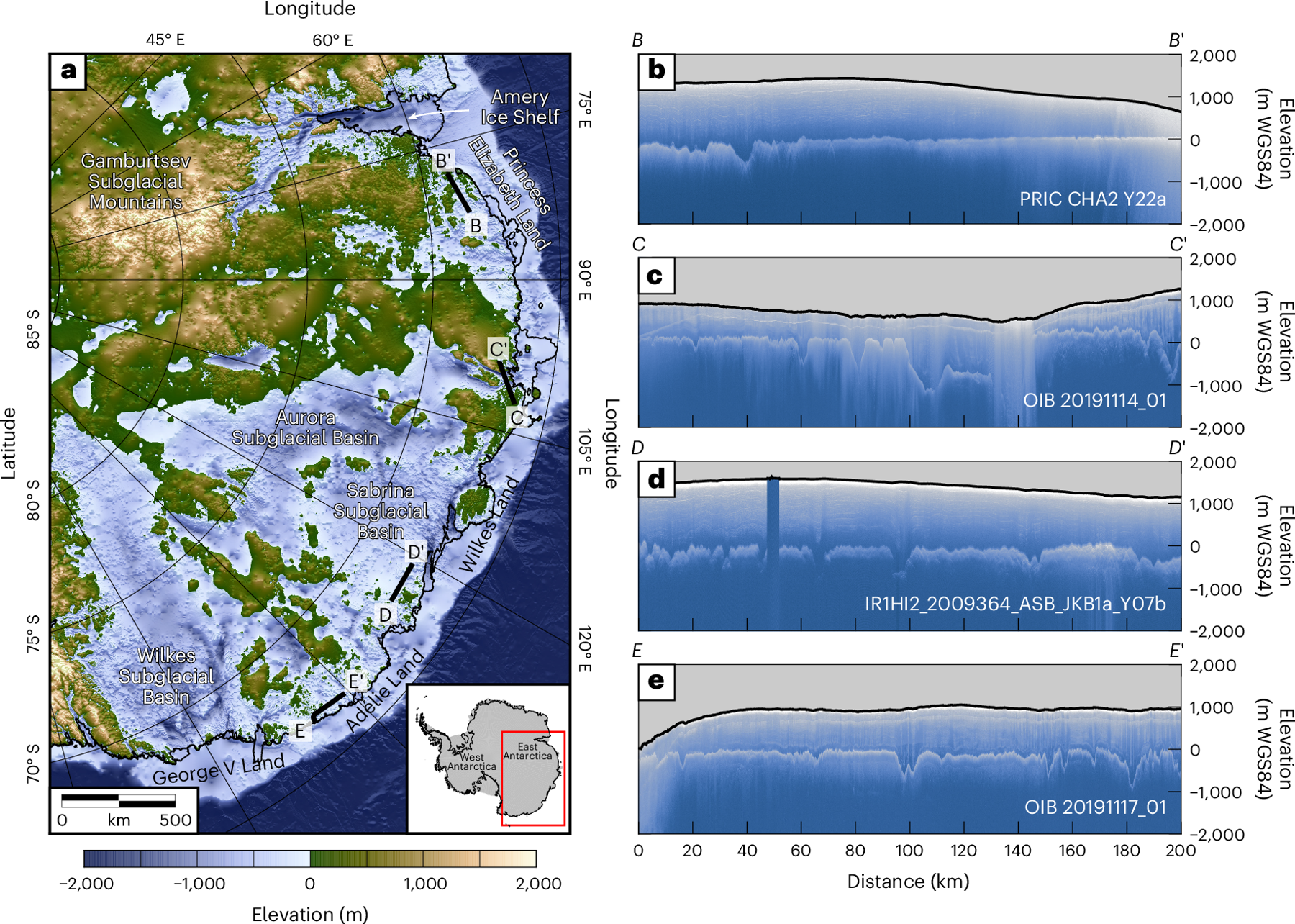
Map of East Antarctic bed elevation and four measured radar profiles from Paxman and colleagues’ 2025 study. This is mapped and radar-derived geology beneath the ice, not an excavation or image of ancient buildings.
Paxman et al., Nature Geoscience 18, 724–731 (2025), doi:10.1038/s 41561-025-01734-z, figure 1. CC BY 4.0. Full figure retained; proportional resize if needed.
Data visualization, not direct optical photography below the ice. Preserve panel letters, axes, legends and study link. Figure 1 uses BedMachine v3 and survey radargrams; figure 3 includes modeled thermal state. Do not imply human settlement.
Image source record · Reuse terms
Image rights and evidence limits
CC BY 4.0 article; figures included unless separately credited. No exclusion found for these figures. Publisher HTML downloaded and license verified.
Image existence does not prove a linked claim. Consult image-specific captions and reuse conditions.
Sources and what they support
Links document the record, the claim’s circulation, an assessment, or reuse terms as labeled. A source link is not automatically corroboration.
- role not specifiedhttps://www.bas.ac.uk/news/ancient-river-landscapes-discovered-beneath-east-antarctica/
- image reproduction provenance; not proof of a linked interpretationhttps://www.nature.com/articles/s41561-025-01734-z
- image reuse conditionshttps://creativecommons.org/licenses/by/4.0/
Connected records
These are contextual links, not automatic corroboration.
- When Antarctica Was Green
Related creator video. Scientific context for reconstructing older Antarctic environments. Vegetation in geological deep time does not establish a lost human civilization.
Explore the same topic
- science misinterpretation
ANITA as proof of a backward-time universe
Anomalous observations did not establish this conclusion.
- optical-phenomenon interpretation
Antarctic sunlight reflects off a solid firmament
Teyit identified ice halos and sundogs, not evidence of a solid dome.
- anomaly interpretation
Bloop as an unknown giant animal
NOAA identifies an Antarctic icequake, not an animal.
- supported scientific explanation
Chlorine and bromine ozone destruction
Supported by measurements; included separately from conspiracy claims, not an unresolved mystery.