
BANZARE expedition surveys, 1929–1931: chart published in 1939
This chart records explorations and surveys of the British, Australian and New Zealand Antarctic Research Expedition of 1929–1931. UTA identifies the creators as the Royal Geographical Society and Douglas Mawson, and gives the archival date as 1939.
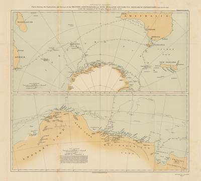
Royal Geographical Society; Douglas Mawson. UTA Libraries Special Collections, identifier 20188940.
UTA limits downloaded or printed content to non-commercial personal or educational use, including applicable fair use. Included as an educational catalogue preview; this is not unrestricted rights clearance.
Scope and limitations
Expedition dates and publication date are distinct. The repository preview is a small reproduction; the original source is needed for close reading of the map labels. This is not a modern coastline dataset.