
Polar & expedition maps
Geological map of Antarctica (entire continent)
A geological compilation uses a color key around Antarctic coastal regions and includes a separate peninsula inset. UTA identifies the sheet with Antarctic Map Folio Series folio 12.
View original institutional record →
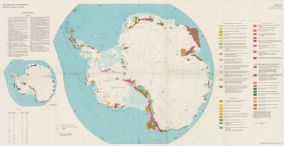
A geological compilation uses a color key around Antarctic coastal regions and includes a separate peninsula inset. UTA identifies the sheet with Antarctic Map Folio Series folio 12.
American Geographical Society; digitized by University of Texas at Arlington Libraries
Image context and reuse
UTA permits non-commercial personal or educational use. This educational catalog retains attribution; other reuse may require contacting UTA Special Collections. No blanket rights clearance is asserted.
Original source and full reproductionObject and edition
- Holding institution
- University of Texas at Arlington Libraries, Special Collections
- Artifact date
- 1970
- Creators
- American Geographical Society
- UTA identifier
- 20188915
What this establishes
Colored geological units are interpreted map categories, not a photograph of exposed bedrock across the continent. Blank or ice-covered areas should not be read as evidence of absent geology or complete subsurface knowledge.
Review scope
Institutional metadata and preview image checked on November 3, 2026. The source provides the full reproduction; individual annotations and all historical interpretations have not been independently authenticated.