
Polar & expedition maps
Map of the Region from the Ross Sea to the Souith Pole Showing the Routes of the Various Flights and Sledge Trips made during the Byrd Antarctic Expedition 1928-1930
Plate I from The Work of the Byrd Antarctic Expedition 1928–1930 places flight and sledge routes on a map with an inset and accompanying text.
View original institutional record →
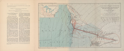
Plate I from The Work of the Byrd Antarctic Expedition 1928–1930 places flight and sledge routes on a map with an inset and accompanying text.
American Geographical Society; digitized by University of Texas at Arlington Libraries
Image context and reuse
UTA permits non-commercial personal or educational use. This educational catalog retains attribution; other reuse may require contacting UTA Special Collections. No blanket rights clearance is asserted.
Original source and full reproductionObject and edition
- Holding institution
- University of Texas at Arlington Libraries, Special Collections
- Artifact date
- 1930
- Creators
- American Geographical Society
- UTA identifier
- 20188863
What this establishes
This is a route plate for the 1928–1930 expedition, distinct from the 1934 promotional map for the second expedition. The catalog title’s spelling "Souith" is retained; routes represent the publication’s account rather than independent verification of every journey.
Review scope
Institutional metadata and preview image checked on November 3, 2026. The source provides the full reproduction; individual annotations and all historical interpretations have not been independently authenticated.