
World maps & models
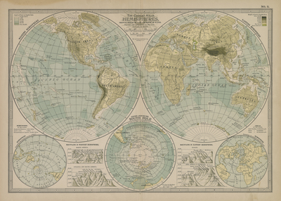
The Century Atlas Hemispheres, Showing Height of Land and Depth of Water
An atlas plate combines large hemispheres with smaller polar views. Color distinguishes mapped land elevation and water depth in a late nineteenth-century world view.
View original institutional record →
An atlas plate combines large hemispheres with smaller polar views. Color distinguishes mapped land elevation and water depth in a late nineteenth-century world view.
Century Co.; digitized by University of Texas at Arlington Libraries
Image context and reuse
UTA permits non-commercial personal or educational use. This educational catalog retains attribution; other reuse may require contacting UTA Special Collections. No blanket rights clearance is asserted.
Original source and full reproductionObject and edition
- Holding institution
- University of Texas at Arlington Libraries, Special Collections
- Artifact date
- 1897
- Creators
- Century Co.
- UTA identifier
- 20186372
What this establishes
The colors encode the atlas presentation of relief and ocean depth; they are not satellite imagery or modern measurements. Antarctica should be read within the plate’s 1897 information context.
Review scope
Institutional metadata and preview image checked on November 3, 2026. The source provides the full reproduction; individual annotations and all historical interpretations have not been independently authenticated.