
World maps & models
A Map of the World in Three Sections Describing the Polar Regions to the Tropics In which are traced the Tracts of Lord Mulgrave and Captain Cook Towards the North and South Poles and the Torrid Zone or Tropical Regions with the New Discoveries in the North Sea
Two circular polar views sit above a long tropical strip, allowing the reader to compare the polar regions with lower latitudes on one sheet.
View original institutional record →
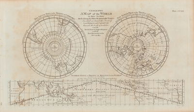
Two circular polar views sit above a long tropical strip, allowing the reader to compare the polar regions with lower latitudes on one sheet.
Constantine John Phipps; James Cook; digitized by University of Texas at Arlington Libraries
Image context and reuse
UTA permits non-commercial personal or educational use. This educational catalog retains attribution; other reuse may require contacting UTA Special Collections. No blanket rights clearance is asserted.
Original source and full reproductionObject and edition
- Holding institution
- University of Texas at Arlington Libraries, Special Collections
- Artifact date
- ca.1776
- Creators
- Constantine John Phipps; James Cook
- UTA identifier
- 20174081
What this establishes
The approximate date "ca.1776" is retained from the institutional catalog. The three sections are different cartographic views, not three physically separated worlds. Fine voyage annotations require the full source reproduction.
Review scope
Institutional metadata and preview image checked on November 3, 2026. The source provides the full reproduction; individual annotations and all historical interpretations have not been independently authenticated.